Ride for Saturday, 02 Feb
Went out for a ride with Andrew, son of a friend who just got himself a new bike - unfortunately a department store bike, since someone bought it for him. I took the mountain bike, since we were planning on trying the rails to trails trail on the way to Tantallon. The trail was fine for about 8km or so, then we got to a section that was marked "rough section"... There were potholes, undulations, piles of loose pebbles, and the crowning glory was a shady section that was still covered in a 6 inch deep mixture of snow and slush. We got to Tantallon and stopped off at the gas station and got some food and more water, then headed back. We went back on the road all the way to the part where the trail crossed the road and became non-"rough section" again. We rode along there for a few km till we hit a slightly waterlogged section, then went back on the road and kept on the road all the way back. I had a bit of fun coming through the mall section, full of Saturday afternoon drone traffic stop-starting through the traffic lights, so I wove my way to the front of the line and out-accelerated the traffic when the light turned green. There was one minivan driver in particular that was edging forward, I think he was a bit surprised to see me get up to 45km/hr and take a bend at a near 45 degree angle (or so it felt).
A fun ride out, all in all. Our route looked something like this (modulo the sections where the GPS ran out of battery power and I didn't notice for a while):
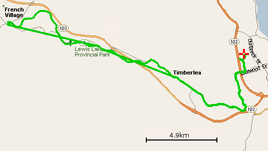
Distance logged: 53.912km
Time: 2:33:37
Average speed: 21.14km/hr
Temperature: 7C, sunny but breezy
Cumulative distance: 1146.479km
A fun ride out, all in all. Our route looked something like this (modulo the sections where the GPS ran out of battery power and I didn't notice for a while):
Distance logged: 53.912km
Time: 2:33:37
Average speed: 21.14km/hr
Temperature: 7C, sunny but breezy
Cumulative distance: 1146.479km
posted by steve at 4/02/2005 10:12:00 pm
![]()


2 Comments:
Hey dude! How do you make those fine maps?
/Johan
Well, it's a bit fiddly, and all based around Linux. What I do is:
1. Download the tracks with gpspoint.
2. Use a Perl script called gpspoint2gpsdrive.pl (part of gpsdrive) which converts the tracks to gpsdrive format.
3. Load the tracks into gpsdrive.
4. Take a screenshot of the gpsdrive window.
5. Use gimp to extract just the section I'm interested in, move the map scape over, and save the image.
Once you do it a few times it's not too bad, I can bash out a map in 5 minutes or so now. The fiddliest bit is cleaning the map up in gimp,
Cheers, Steve
Post a Comment
<< Home